

Tobacco Barn Hollow
Trail Description
Before you go…
Scroll down for directions.
You are entering a highly protected nature preserve. Regulations exist to protect the preserve’s natural communities from the impact of public visitation. Please follow these regulations to leave Tobacco Barn Hollow as pristine as you found it. Remain on trails at all times and walk in a single file to protect the bulbs of native wildflowers bordering the trail - bulbs that are very vulnerable to soil compaction. Do not disturb, pick, or collect flowers, plants, rocks, or wildlife. Hunting, caving, fishing, trail biking, rock climbing, wading, campfires, and swimming are prohibited. Click here for a list of full regulations.
Dogs are permitted at Tobacco Barn Hollow on a 6 ft. leash. A dog owner’s guide to hiking Arc Trails.
Interpretive Kiosk: Interpretive kiosks are situated at both trailheads. We encourage you to take a picture of the trail map with your phone before heading out on the trails.
Trails are open from sunrise to sunset. Note: Parking lots are not winter-maintained. Do not hike on trails when they are impacted by heavy rain, ice, or snow. Note that trails are closed during the annual deer management hunt, which takes place on 1) Monday through Sunday the week following Thanksgiving, and 2) Saturday and Sunday before Christmas.
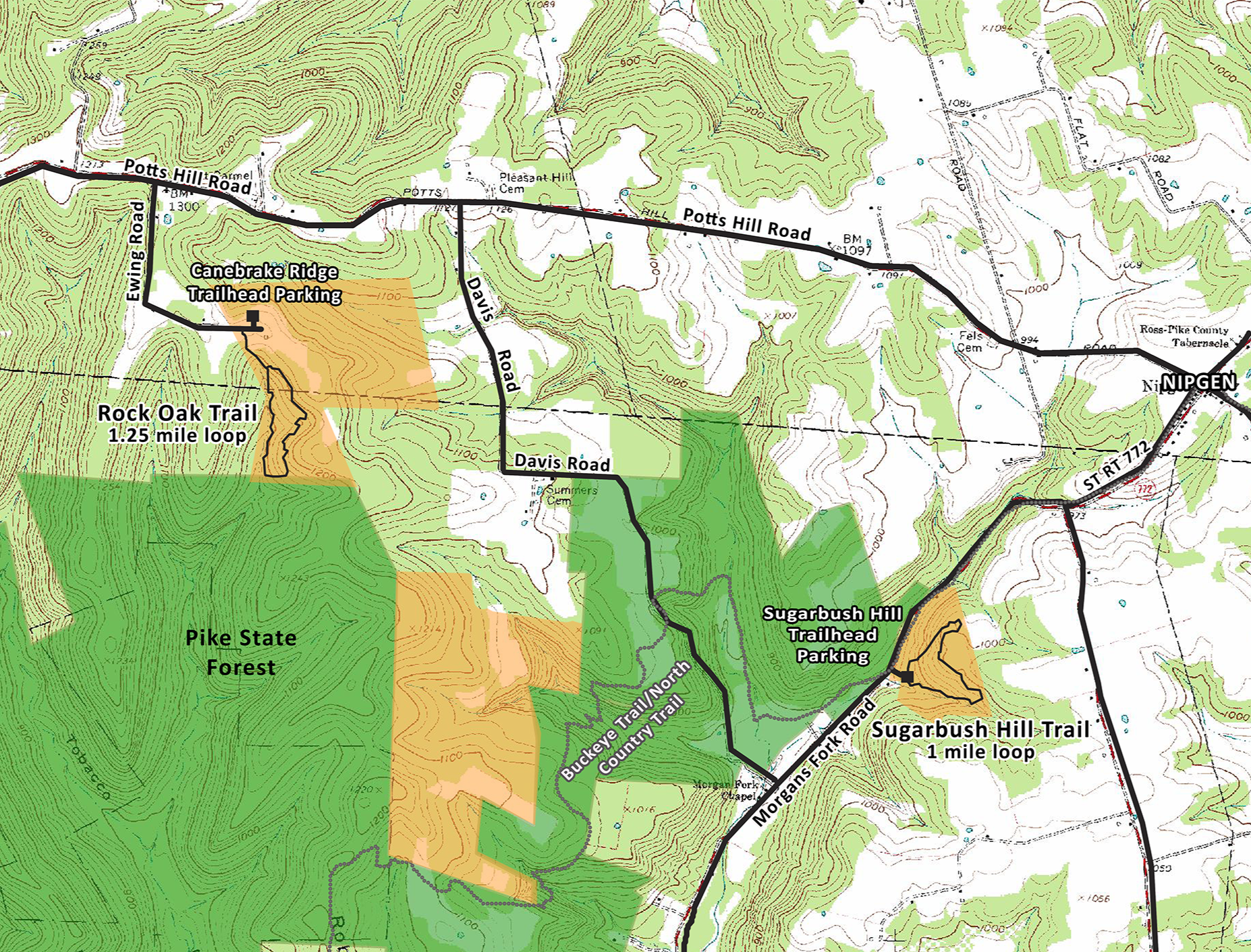
Tobacco Barn Hollow’s Trails:
Hiking Trails’ Difficulty - moderate to challenging. Both the Rock Oak Trail and Sugarbush Hill Trail are considered moderate to difficult hikes because of the landscape’s uneven terrain. The trails are designed for gradual climbs, however, and avoid short steep ascents.
Rock Oak Trail - 1.25-mile loop. Begin at Canebrake Ridge Trailhead on Ewing Road. Rock Oak Trail is an alternative name for Chestnut Oak, the predominant tree species in this rugged, upland forest. The trail first winds through a young, successional woods before entering a beautiful, healthy, intact forest that supports a high diversity of salamanders, birds, insects, and reptiles. It follows a small headwater stream that gradually grows in size the further it descends, eventually draining into the major ravine of Tobacco Barn Hollow. On the trail’s return ascent, it passes through groves of mature oaks and hickories, the forest bearing a classic Appalachian understory of acid-tolerant plants.
Sugarbush Hill Trail - 1-mile loop. This trail begins at the Sugarbush Hill Trailhead on Morgans Fork Road. The trail takes visitors on a moderate climb up a rocky path along a boulder-strewn cascading stream. At the top of the hill, visitors are rewarded with panoramic views of the densely forested Appalachian hills of Pike State Forest. The trail then takes hikers on a moderate descent through a forested hillside with immense maples, hickories, oaks, and tulip poplars back to the trailhead parking area. The trail is accessible from both the Buckeye and North Country Trail.
Directions to both trailheads:
Address: Canebrake Ridge Trailhead - 700 Ewing Road, Bainbridge, OH 45612 39.193801, -83.203656
Directions: The Tobacco Barn Hollow Canebrake Ridge Trailhead is south of US-50 and east of Bainbridge, OH. From US-50: Just east of Bainbridge, turn south onto Potts Hill Road. At the top of the hill, you will come to a fork. You’ll see signs pointing to the right for Pike Lake Road. Veer left to stay on Potts Hill Road. Continue on Potts Hill for another 4.2 miles, passing Mitchell Road on your right, and Landrum Road on your left. The next road on your right is Ewing Road. Turn right and drive all the way to the end of the road. The preserve is signed, and the trailhead parking lot will be on your left (north). Park in the gravel parking lot, and the trail begins across from the parking lot on the south side of Ewing Road.
Address: Sugarbush Hill Trailhead - 6870 Morgans Fork Rd, Waverly, OH 45690 39.17865, -83.16667
Directions: The Tobacco Barn Hollow Sugarbush Hill Trailhead is south of State Route 772 and Nipgen, OH. From Chillicothe: Take OH-772/S Paint Street 16 miles south until you see signs for Nipgen. After you pass the intersection of OH-772 and Potts Hill/Nipgen Road, continue straight for approximately 0.6 miles, then veer right onto Morgans Fork Road. In 0.8 miles, the signed parking lot will be on your left. From US-50: Just east of Bainbridge, turn south onto Potts Hill Road. At the top of the hill, you will come to a fork. You’ll see signs pointing to the right for Pike Lake Road. Veer left to stay on Potts Hill Road. Continue on Potts Hill for another 5 miles until you reach the intersection of Potts Hill/Nipgen Road and State Route 772. Turn right on State Route 772 and continue straight for approximately 0.6 miles, then veer right onto Morgans Fork Road. In 0.8 miles the signed parking lot will be on your left.